
History of The Downs
Note to Readers:
Click on any image to see a larger version.
Review additional historical resources in the Downs History Gallery and Documents.
By Carole Falk
We may not know whose feet first walked upon the soil of our peninsula but in the early 1980's, Dick Johnson, past president of the Anne Arundel Archaeology Society, trod the ridge overlooking the Severn. In his walks he found a considerable Native American presence: "there was a diverse style of points (aka arrowheads) found " but the Middle Woodland (AD 200 to AD 900) period seems to dominate.
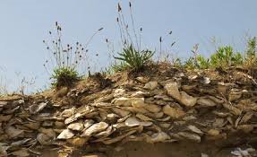
Near Lots 137,138 and 139 was an extensive midden (garbage dump of oyster shells) that was later excavated by archaeologists. Every natural ramp leading up the ridge from the river or the creeks had Indian material and discarded oyster shells. Dick urged our then teenage son Andrew, an amateur archaeologist, to excavate a large midden at the site of the future home foundation for Lot 132. Andrew found shells and artifacts dating to several periods of Native American habitation.
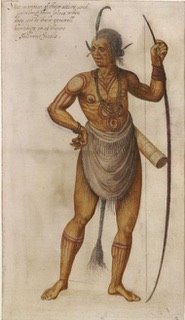
According to Al Luckenbach, Archaeologist of Anne Arundel County, the original Algonquin speaking natives, who named most of the Chesapeake Bay rivers, had settled in this area possibly because of the rich oyster presence. Sometime at the beginning of the 17th century, the warlike Susquehannocks from Pennsylvania, armed with guns obtained from the French, motivated the Algonquins to move south to the mouth of the Patuxent. Dr. Luckenbach asserts that the victors foraged and hunted but did not settle in permanently, leaving Anne Arundel County as a no man's land, a buffer zone between the tribes. But it was not to be uninhabited for long: when Captain John Smith discovered the Chesapeake Bay during his explorations in the early 1600s he also documented the native tribes. Alas, ignoring their presence, King Charles of England awarded the whole of Maryland to the second Lord Baltimore in 1632.
The primeval forested Downs land gave way to cultivation with the arrival of the Puritan settlers in the 1600s. The original land grants map of 1650 shows our community as mainly comprised of two large parcels: one was granted to William Crouch and the other to Matthew Howard. The farms were bequeathed to several heirs and subsequently changed hands many times.

In 1649, English Puritans arrived on the shores of Anne Arundel County. With no natives around to recount the names of places, they named their town Providence and as well conveyed English names to the surrounding rivers such as the Severn, West, and Rhode. Zeroing in on our community, the first written records are located on the original land grants map of 1650: A large parcel was granted to Matthew Howard and a smaller one to William Crouch. Crouch subsequently added to his property while an adjacent property was awarded to Matthew Howard in 1696. Dr. Al Luckenbach, Anne Arundel County Archeologist, theorizes that the two men were probably upper middle class tobacco planters.
While tobacco was the dominant crop in the early economy, Dr. Luckenbach states that it was very labor intensive and many indentured servants were employed until slaves became more prominent in the 1700’s. By the mid 18th century, our land would have been used to grow wheat and corn. Finally in the 19th century, our properties consisted of "truck farms" that harvested beans, vegetables and fruits and other garden produce for Baltimore markets.
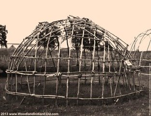
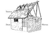
Houses nowadays in the Downs display various architectural styles and a variety of sizes. Contrastingly, the earliest settlers lived in oval wigwams of sapling supports covered with bark panels. The later English settlers lived in earthfast dwellings supported by sturdy wooden posts sheathed with wooden siding. Their chimneys were often built with a wooden lattice and plastered with a pasty mud called wattle and daub. Dr. Luckenbach says the houses lasted about 30 years. The interiors were spare; rough mattresses on the floor served as bedding and simple benches and chairs served as seating in front of a plain wooden table. The colonists stored their valuables in wooden chests, secured with padlocks.
Around 1700 brick houses began to appear and possessions would have reflected the prospering colonists' access to world trade. So if your landscaping turns up a piece of blue and white china, it could possibly be a piece of Delft or Chinese export ware! A Downs resident, Tom Hughes, once turned up blue and white china plates near a huge tree that had fallen in the rear of his property.
Speaking of china evokes food. The settlers harvested oysters and crabs, kept pigs and chickens, grew corn and berries, and raised cattle for dairy products. The pigs and cattle were free-range; fences only existed to keep the roving animals out of one's kitchen garden! By 1835 Dr. Hyde Ray, a surgeon in Annapolis, inherited what was by then known as Howard's Discovery and his property also included part of the adjoining Crouchfield; the property at that point was what we call home. After Ray's death the property was in litigation between his wife and daughters. Mrs. Ray won the right to sell and in 1863 Henry Hopkins bought the property. Various owners prevailed until only the Howard's Discovery portion was sold by Col. William Hoynes to Mr. William Cochran, president of the Sherwood Forest Club, Inc., in 1920 for $47,599. According to Smothers, Open Those Old Brown Gates, a recently compiled history of Sherwood Forest, Mr. Cochran planned to develop it into an 18-hole golf course.
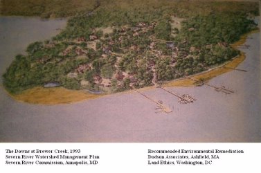
After Mr. Cochran purchased the property that is now the Downs peninsula (beginning at Coventry Court and including all the land to the Severn River and between the creeks), he hired a nationally renowned golf course designer, Herbert Strong, from NY. The course was built and opened on May 22, 1923 as the South Forest Golf Club. A cable-drawn ferry took the Sherwood Forest golfers across Brewer Creek to the course. There was also a path-road that bridged the headwaters of Brewer Creek. (And it's still there on some Downs properties, originally paved for golf carts.)
By the spring of 1928, plans were afoot to develop the course into a golf course community. Three houses were erected on the left side of the 18th fairway, near the junction of Brewer Creek and the river. Eventually the three homes built there were floated across Brewer Creek to Sherwood Forest proper when plans were abandoned for further housing development. (Not so crazy to do since original Sherwood Forest houses were built on pilings.)
Golf continued to be played on the course until Oct. 15,1942 when it was closed for the next five years due to a wartime manpower shortage and rationed gasoline. During the war German POWs mowed the grass on the course. After the war Ed Graefe (a Sherwood Forest resident and professional golfer) cleared the wildly overgrown property and by the early 1960's all 18 holes were restored. He leased it from 1947 until 1972 from Mr.Cochran's daughter Anne and her husband, Redmond Stewart (who managed the property). Eddie swears that Spiro Agnew played golf there as Vice-President!
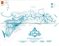
The Stewarts decided to sell the property and in 1971, Joe Jenkins, a developer, purchased the South Forest golf course as well as property encompassing part of the original Crouchfield land grant that ran from Coventry up Coachway to Sherwood Forest Road and the property now known as Carriage Hills. By 1972 he developed a master plan that details a new nine-hole golf course, golf driving range, two small lakes, recreation fields, horse trails, and even a prayer house to be developed. As well, it show that the main entrance-exit for the Downs would be more or less where the current main street for Carriage Hills is and would bridge a deep ravine to then join into Westminster. The master plan shows the waterfront developed into home lots. The master plan of 1972 was an ambitious wish list indeed! Around that time Jenkins took a trip to England and became smitten with all things British. Thus it seems that Anglophilia determined the name of the new community; unfortunately it is a misnomer. The real downs are two parallel ranges of chalk hills in southeast England that serve as sheep pastures! Odd then that our covenants prevent the acquisition of sheep!
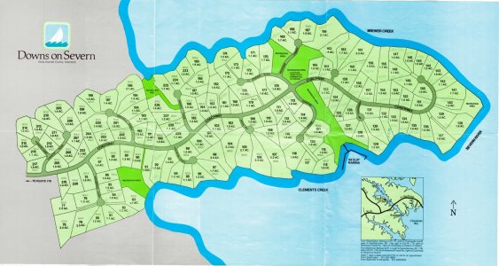
In any case, on January 1, 1973 the Downs Yacht and Country Club was incorporated and all the streets were given proper British names. Perhaps Mr. Jenkins envisioned himself driving down Coachway in an open, British racing green MGTD while accessorized with driving gloves, scarf and cap. By 1973 when the Downs Yacht and Country Club was incorporated, the original 1650 land grants of Crouchfield and Howard's Discovery had undergone their last transformation from farms to golf course to a suburban community.
Joe Jenkins, sold lots, established the two marinas and eventually razed the old golf course clubhouse. A road to be dubbed Coachway was bulldozed from the remaining front nine holes to an intersection with Sherwood Forest Road. By July 1978, the entire back nine of the Sherwood course was gone and divided into lots. Homes had been built on Coachway and on Canterbury Common, Trinity and Westminster. But trouble was brewing. A main entrance onto Generals Highway where Carriage Hills is now located was not feasible. Anne Arundel County Dept. of Planning and Zoning would not allow a bridge-road over the ravine that separates that area from the Downs. By 1975-6 a dip in the housing market and other economic factors forced Jenkins to throw in the towel and declare bankruptcy; A development company from Atlanta, GA, purchased the property. A full color brochure from that time depicts the golf course, still undeveloped, with sailboats on the Severn. The text states, "The roads are in, the utilities are under. Your land is awaiting your devise."
Most homes in the Downs have changed hands over the years, but there are several residents who have lived here since the beginning. In the summer of 1972, Dave and Ann Hargett were looking at lots in Saefern but were daunted by the prices for putting in a driveway over some of the ravine properties. Col. Elliot Powell, developer of Saefern and owner of Powell Realty, told them of a community to be developed on the other side of Clements Creek. He took them to meet the Downs developer Joe Jenkins; they toured the property and at that time most of the lots were not yet designated or priced. They decided to buy their lot (#4), which was the first lot sold for Ed Rodowsky, a new agent for Powell Realty. Ed took Dave for a celebratory lunch at the Roy Rogers in downtown Annapolis. Dave remembers the specific date, Sept. 8, 1972 because of two events: he had been injured in a baseball game, and his wife Ann was in the beginning stages of labor! According to Dave and verified by several other early residents, it seems that Joe Jenkins was a scamp. Allegedly, he tried to turn the then prospective marina into a commercial entity and the clubhouse into a public restaurant, apparently didn't pay taxes, and sold the same lot to several people. Whew!
While the Hargetts may have been the first lot owners, Dorrie and Charles Harrison became the first residents (lot #2) in late 1972. Dorrie's story also focuses on the real estate agent, Ed Rodowsky. It was quite muddy when she came to see lots and her shoes got stuck in the mud. The agent drove her to Montgomery Ward (the first store at the prospective Annapolis Mall and which her husband managed) and bought her a pair of rubber boots. Then the boots got stuck in Downs' mud! But her spirits didn't sink with the boots; they did buy their lot and build their house. Dorrie later worked at the deckhouse model, the first house on the left as one enters the Downs. She remembers that a guard sat at the present Downs entrance to Coachway since at that time the to-be-developed roads were planned to be private, as in Sherwood Forest. According to Dorrie, Jenkins had to relinquish control over the roads to the county because he did not have the money to maintain them. The guard soon disappeared.
Dot Warfield, her late husband Buzz, daughter and son moved to the Downs in 1976. Both Dot and Buzz were active in the community; Buzz was on the architectural committee and afterwards, community President.
Jenkins became bankrupt and the property was seized by its creditors. Dot went to the county courthouse to see what would become of the properties. She emphasized how stressful life was back then because few of Jenkins'
promises came to fruition.
But life got better.
After the sale of the Downs to the Georgia development company, a VP named Gary Pyles was assigned to manage the property. He soon set up his own company, the Annapolis Development Corporation. Tom and Sharon Hughes, living here since 1977, began selling lots for Pyles in 1980. After several years Pyles had accumulated enough assets to develop several properties in Anne Arundel County including Carriage Hills, which he spun off from the Downs, and South River Colony. He unfortunately lost most of it in the Savings and Loan-real estate debacle of 1985-6 and became a gentleman farmer in Bucks County, Georgia.
Nothing to do with Mr. Pyles, but one of Tom's memorable moments from the 1970's involved a huge tree that fell in the rear of his property. He was clearing the debris when he unearthed what very well might have been a garbage dump of old but imported blue and white china plates. He toted them to his garage and stored them there until one day when he sheepishly admits taking them to the dump. Another vivid memory is of large twenty-five pound feral cats, living at the very rear of his property, which chased his small cock-a-poo home. The dog never explored so distantly again!
Melanie Wilhelm Dunaway moved to 972 Coachway (Lot 37) in 1974, as a young child with her parents who still reside there. Her memories include ice-skating on the Sherwood Reservoir when it froze in 1976. In order to get there the children had to scale the hill behind Coventry Place where new homes were being built. She well remembers running around the community looking at houses as they were being constructed. A flag lot that sported a swimming pool in its front yard on St. Albans Square especially intrigued her. Many years later when Melanie decided to move back to the Downs, she purchased that very horseshoe shaped home (Lot 12) and renovated it. The Downs has been a most fortunate association for Melanie: she met her now husband, Jeff Dunaway, at the home of friends Richard and Patty Soppe. Melanie's and Jeff's union resulted in the ownership of two homes in the Downs, one of which they will later sell.
Risa Hyman has the distinction of being the first secretary of the board of directors. She moved here in 1975 (lot 22) with her late husband Bruce and two children. Her house was one of the three models for Ryland Homes while the other models were Lots 23 and 26. Only one other Ryland home was ever built: Lot 18. Risa reports that the old Sherwood Forest clubhouse was a beautiful old building but developer Pyle did not want it so tall as to loom over the houses below on Coachway. He razed it and erected the present structure about 6 feet lower. One day Risa noticed that there was no insulation whereby she got a stop work order. Our clubhouse now has insulation thanks to Risa.
Risa obviously has a good eye: she found cannonballs in her backyard that, after research, turned out to be from the War of 1812. Perhaps they match the era of Tom Hughes' dishes!
The land under our feet now welcomes 21st century settlers who will nurture and tend it differently but just as carefully as those who walked upon it over the centuries.
Pages
- Home
- SHOUT OUT to the Downs
- Directories
- Historical Stuff
- History of The Downs
- Historical Downs Photos
- Historical Downs Documents
- Newsletters
- Public Safety Information
- Traffic Safety
- Traffic Safety Contractor Handouts
- Classified Ads
- Community Documents
- Board Meeting Documents :
- Covenants and Bylaws
- Neighborhood Map
- Committees and Working Groups
- Committee and Working Group Docs
- Marina Matters
- Clements Creek Marina
- Vacant Slips at Clements Creek
- Applying for a slip
- CCM Fees
- Dinghy Rack Rules and Applications
- Temp Slip fees for Friends of DPOA
- Brewer Creek Marina
- Migratory Bird Nesting Laws
- Marina Replacement Project
- CCM Replacement Public Notice
- Marina Replacement Discussion
- Bulkhead Replacement Project
- Pool
- Swim Team - Downs Devilrays
- Devilrays Information
- Devilrays Calendar
- Devilrays Documents
- Devilrays Team Photos
- Visitors Information
- Community Amenities
- Getting Here
- Properties for Sale
- Visitors Photo Gallery
- Contact Us
- Website Policies
- Community Photo Galleries